 FLYSCOUT
What is MLAT? Why some positions on a flight tracker are estimates
MLAT, or multilateration, is how flight trackers place aircraft that do not broadcast their own position. Several receivers hear the same signal from the aircraft's transponder, and the tiny differences in when it arrived at each one fix where it came from. It works well, but it is a calculation, not the aircraft's own report, and now and then it is badly wrong.
Most positions on a flight tracker are sent by the aircraft itself: its ADS-B transponder broadcasts where satellite navigation says it is, about once a second. Some aircraft send no position at all, yet still appear on the map. Those positions were worked out on the ground, by multilateration.
How multilateration works
An aircraft's Mode S transponder replies to radar and sends other short messages, with its identity and height, even if it does not broadcast a position. Every receiver that hears one of those messages notes exactly when it arrived, against a very precise clock.
Because the signal travels at the speed of light, it reaches a receiver 30 km away a little later than one 10 km away. Compare the arrival times at several receivers whose positions are known, and there is only one place the signal can have come from. That is the aircraft's position. Flightradar24 calls the method by its technical name, time difference of arrival.
The method needs several receivers to hear the same message: Flightradar24 needs three since January 2025, after needing four before; FlightAware also uses three or more, and ADS-B Exchange four.
Which aircraft are placed by MLAT
- Older civil aircraft with Mode S transponders that do not broadcast ADS-B positions.
- Many military aircraft, which carry transponders but often do not broadcast where they are.
- Aircraft whose own positions are unreliable, for instance where satellite navigation is jammed. Flightradar24 says MLAT also helps to work around jamming and spoofing.
ADS-B Exchange's map labels each aircraft by its source, so you can tell an aircraft's own ADS-B position from an MLAT one.
How accurate it is
Flightradar24 gives MLAT positions as accurate to 10 to 20 m at best, 10 to 100 m typically, and up to 1,000 m in rare cases. Speeds worked out from MLAT positions are often wrong in turns, and the positions arrive a few seconds later than ADS-B ones.
Coverage depends on receivers being close together. Because several of them must hear each message, MLAT works best at height, over areas with many receivers. Over Europe and North America, Flightradar24 says, MLAT coverage generally starts at 5,000 to 10,000 ft; below that, an aircraft without ADS-B can drop off the map even though air traffic control still sees it.
Why MLAT tracks zigzag
Scatter of a few hundred metres either side of the true path is enough to make a track look jagged: the aircraft seems to weave, which no aircraft actually does. Now and then, a bad patch of calculations puts an aircraft miles away for minutes at a time, and then it seems to jump back.
FlyScout has seen both. When a KC-135 tanker's MLAT track drew zigzags no aircraft can fly, and another's calculated positions sat 20 to 27 NM off its real racetrack for a quarter of an hour, FlyScout learned to treat calculated positions as estimates, not facts.
How FlyScout treats calculated positions
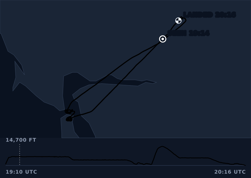
A position the aircraft sent itself is never moved. A calculated one is checked against what the aircraft itself reports about its speed and course: one that the aircraft could not have reached is dropped, and the rest are put on the path the aircraft says it was flying. A finding whose path was mostly calculated says so, as the U-2 above does.
The rules that find unusual flights measure the cleaned track, so a jagged MLAT line cannot pass for a pattern that was never flown.
Questions people ask
What does MLAT mean on Flightradar24?
It means the position was calculated by Flightradar24's receivers rather than sent by the aircraft. The aircraft's transponder answered radar or sent other messages, and the receivers that heard them worked out where it was from the differences in arrival time.
How accurate is MLAT?
Usually accurate to tens of metres. Flightradar24 gives 10 to 20 m at best and 10 to 100 m typically, with rare errors of up to 1,000 m; speeds calculated from MLAT are often wrong in turns. Occasional bad patches can put an aircraft much further off for minutes at a time.
Why do some aircraft need MLAT?
Because they do not broadcast ADS-B positions. Older civil aircraft and many military aircraft carry transponders that answer radar and send their identity and height, but not where they are. MLAT turns those signals into a position.
Why is MLAT only available at higher altitudes?
Because several receivers must hear the same signal, and low aircraft are heard only by receivers close by. Flightradar24 says MLAT coverage over Europe and North America generally starts at 5,000 to 10,000 ft.